My experience mapping trees in Bogota [ENG-ESP]
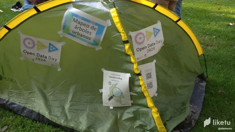
On March 2nd I participated in the OpenDataDay 2024 that took place in the Simon Bolivar Park in the city of Bogotá.
The event is framed within the three stages of mapping urban trees by creating openstreetmap notes, which are:
Stage: Collect open data of trees in different sites in Colombia.
Stage: Basic mapping of trees in OpenStreetMap, through virtual sessions.
Stage: Identification of trees and addition of details in OpenStreetMap, in virtual sessions.
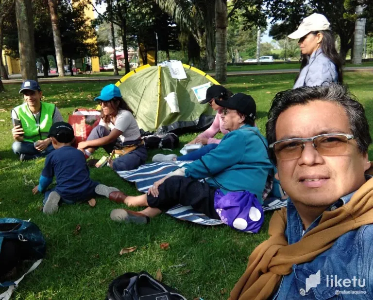
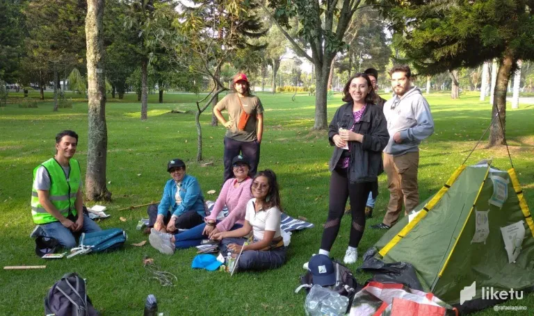
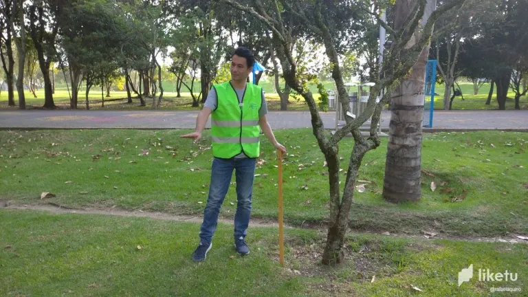
In this opportunity we approached the first stage with the application for Android: StreetComplete. The activity consisted of measuring the diameter and height of the trees, taking two photographs of the tree from different angles and a close-up photograph with details of the leaves and flowers. With all this information the OpenStreetMap notes are created with the StreetComplete app.
All data collected are open (free to use), which when mapped in OpenStreetMap, are under a free license, where anyone can use them.
Parallel to our city of Bogotá this activity was also carried out in: Yopal, Villavicencio, Duitama, Granada and Medellín; where more than 600 notes were created.
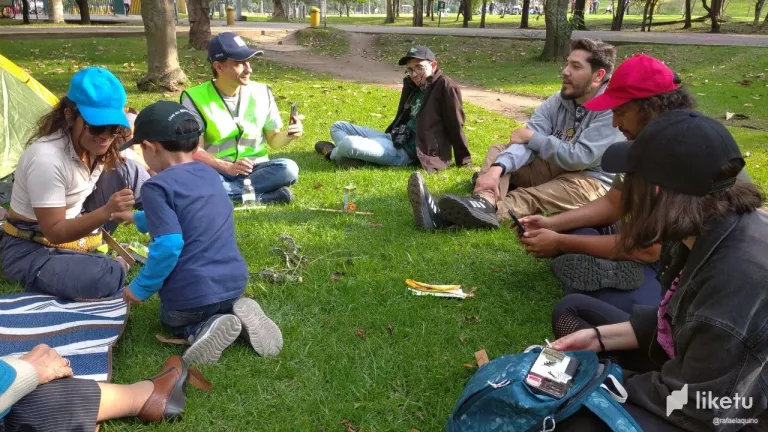
All this event was led by: Andrés Gómez who taught us with a lot of patience how to do the activity.
I feel very happy and excited to join this OpenStreetMap community in the city of Bogota, where this Saturday I was able to personally meet Andres and several people who also participated in the event.
After the activity, our leader Andres Gomez gave us an informative talk about everything related to OpenStreetMap, where I could clarify many doubts.
Undoubtedly the most important of all this is the community that I am joining, which allows me to interact with people who share the same interest. In this small photographic sample I share with you part of the activity.
For additional information: https://pad.osm.lat/s/Wk7YD-uqG#
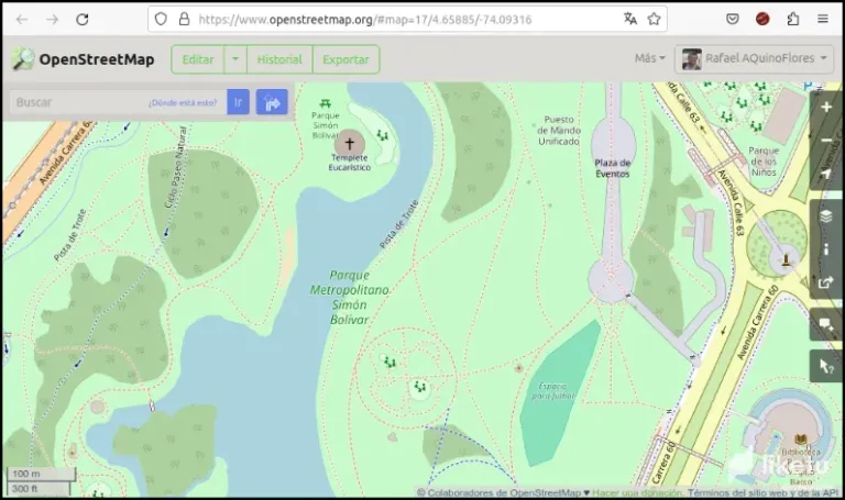
Map source: https://www.openstreetmap.org/#map=17/4.66030/-74.09235
Mi experiencia mapeando árboles en Bogotá
El śabado pasado 02 de marzo participé en el OpenDataDay 2024 que se realizó en el Parque Simón Bolívar de la ciudad de Bogotá.
El evento está enmarcado dentro de las tres etapas del mapeo de árboles urbanos mediante la creación de notas de openstreetmap, las cuales son:
Etapa: Recolectar datos abiertos de árboles, en diferentes sitios de Colombia.
Etapa: Mapeo básico de árboles en OpenStreetMap, por medio de sesiones virtuales.
Etapa: Identificación de árboles y adición de detalles en OpenStreetMap, en sesiones virtuales.
En esta oportunidad abordamos la primera etapa con la aplicación para Android: StreetComplete. La actividad realizada consiste en hacer las mediciones del diámetro y altura de los árboles, tomar dos fotografías de distintos ángulos al árbol además de una fotografía cercana con detalles de la hoja y flores. Con toda esta información se crean las notas de OpenStreetMap con la app StreetComplete.
Todos los datos recolectados son abiertos (de uso libre), los cuales al ser mapeados en OpenStreetMap, están bajo una licencia libre, donde cualquier persona puede usarlos.
Paralelamente a nuestra ciudad de Bogotá esta actividad también se realizó en: Yopal, Villavicencio, Duitama, Granada y Medellín; donde se crearon más de 600 notas.
Todo este evento estuvo liderizado por: Andrés Gómez quién nos enseñó con mucha paciencia como realizar la actividad.
Me siento muy contento y entusiasmado en unirme a esta comunidad de OpenStreetMap de la ciudad de Bogotá, donde este sábado pude conocer personalmente a Andrés y a varias personas que también participaron en el evento.
Luego de realizada la actividad, nuestro líder Andrés Gómez nos dio una charla informativa de todo lo relacionado con OpenStreetMap, donde pude aclarar muchas dudas.
Sin ninguna duda lo importante de todo esto es la comunidad a la que me estoy uniendo la cual me permite interactuar con personas con que compartimos un mismo interés. En esta pequeña muestra fotográfica les comparto parte de la actividad realizada.
Para información adicional: https://pad.osm.lat/s/Wk7YD-uqG#
Fuente del mapa: https://www.openstreetmap.org/#map=17/4.66030/-74.09235
For the best experience view this post on Liketu
Me encantó esta experiencia, es muy interesante y lo mejor es el hecho de hacer comunidad. Las fotos dan cuenta de que fue una actividad enriquecedora. Un abrazo.
Qué actividad tan interesante, no se me habría ocurrido eso de mapear árboles. Es un bonito gesto que mantendrá testimonio de su existencia incluso si desaparecen por el motivo que sea.
@sagarkothari88 vote
Gracias por pasar por aquí. Fue una experiencia única! mucho aprendizaje y un aporte importantísimo, ya que los datos son libres tanto su métrica como las fotografías de los árboles y cualquier persona tiene acceso a ellos.
Saludos, al parecer fue una experiencia bien interesante y didáctica, que bueno que pudieron usar la tecnología en el mapeo de los árboles.
Muy novedosa la idea.
Mis mejores deseos.
!ALIVE
@rafaelaquino! You Are Alive so I just staked 0.1 $ALIVE to your account on behalf of @ osomar357. (1/10)
The tip has been paid for by the We Are Alive Tribe through the earnings on @alive.chat, feel free to swing by our daily chat any time you want, plus you can win Hive Power (2x 50 HP) and Alive Power (2x 500 AP) delegations (4 weeks), and Ecency Points (4x 50 EP), in our chat every day.

En verdad fue muy novedoso para mi y la experiencia fue lo máximo. Gracias por pasar por aquí. Saludos